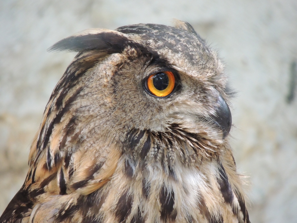
Baykuş Bakışı - Fotoğraf: Veli Görgün |
| ImageDescription | |
| Image title |
| Marka | NIKON |
| Manufacturer of image input equipment |
| Model | COOLPIX P510 |
| Model of image input equipment |
| Orientation | 1 |
| Orientation of image |
| Software | COOLPIX P510 V1.0 |
| Software used |
| DateTime | 2013:08:18 13:01:14 |
| File change date and time |
| YCbCrPositioning | 2 |
| Y and C positioning |
| ExifTag | 2302 |
| Exif IFD Pointer |
| GPSTag | 7662 |
| GPSInfo IFD Pointer |
| Tag#34864 | 1 |
|
| WinTitle | |
| Windows Explorer Title |
| WinSubject | |
| Windows Explorer Subject |
| Tag#59932 | |
|
| ExposureTime | 1,666667E-02 |
| Exposure time |
| FNumber | 5,5 |
| F number |
| ExposureProgram | 2 |
| Exposure program |
| ISOSpeedRatings | 800 |
| ISO speed ratings |
| ExifVersion | |
| Exif Version |
| DateTimeOriginal | 2013:08:18 13:01:14 |
| Date and time original image was generated |
| DateTimeDigitized | 2013:08:18 13:01:14 |
| Date and time image was made digital data |
| ComponentsConfiguration | |
| Meaning of each component |
| CompressedBitsPerPixel | 4 |
| Image compression mode |
| ExposureBiasValue | 0 |
| Exposure bias |
| MaxApertureValue | 3,2 |
| Maximum lens aperture |
| MeteringMode | 5 |
| Metering mode |
| LightSource | 0 |
| Light source |
| Flash | 16 |
| Flash |
| FocalLength | 160,5 |
| Lens focal length |
| MakerNote | |
| Manufacturer notes |
| ISOSpeedRatings | 0 |
| ISO speed ratings |
| UserComment | |
| User comments |
| SubSecTimeOriginal | 00 |
| DateTimeOriginal subseconds |
| SubSecTimeDigitized | 00 |
| DateTimeDigitized subseconds |
| FlashpixVersion | |
| Supported Flashpix version |
| ColorSpace | 1 |
| Color space information |
| PixelXDimension | 4608 |
| Valid image width |
| PixelYDimension | 3456 |
| Valid image height |
| FileSource | |
| File source |
| SceneType | |
| Scene type |
| CustomRendered | 0 |
| Custom image processing |
| ExposureMode | 0 |
| Exposure mode |
| WhiteBalance | 0 |
| White balance |
| DigitalZoomRatio | 0 |
| Digital zoom ratio |
| FocalLengthIn35mmFilm | 900 |
| Focal length in 35 mm film |
| SceneCaptureType | 0 |
| Scene capture type |
| GainControl | 2 |
| Gain control |
| Contrast | 0 |
| Contrast |
| Saturation | 0 |
| Saturation |
| Sharpness | 0 |
| Sharpness |
| SubjectDistanceRange | 0 |
| Subject distance range |
| Tag#59932 | |
|
| Tag#59933 | 4216 |
|
| GPSVersionID | |
| GPS tag version |
| GPSLatitudeRef | |
| North or South Latitude |
| GPSLatitude | -1.#IND:-1.#IND:-1.#IND |
| Latitude |
| GPSLongitudeRef | |
| East or West Longitude |
| GPSLongitude | -1.#IND:-1.#IND:-1.#IND |
| Longitude |
| GPSAltitudeRef | |
| Altitude reference |
| GPSAltitude | -1,#IND |
| Altitude |
| GPSTimeStamp | -1.#IND:-1.#IND:-1.#IND |
| GPS time (atomic clock) |
| GPSSatellites | |
| GPS satellites used for measurement |
| GPSImgDirectionRef | |
| Reference for direction of image |
| GPSImgDirection | -1,#IND |
| Direction of image |
| GPSMapDatum | |
| Geodetic survey data used |
| GPSDateStamp | |
| GPS date |